| For those times when SDS sets in................................ | |||
| (with apologies to the inventors) | |||
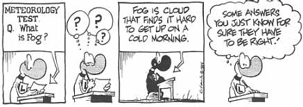
**'The Cloud'** initially The Cloud was found on the BoM forecast!!!!!! after that - it got around some! BUREAU OF METEOROLOGY SOUTHERN TABLELANDS Come on Michael, didn't you see The cloud. I mean It
was The cloud that the bom spoke about. You should show more respect when they talk about
The cloud. If the BoM said there was a cloud, then there is only
one cloud,which makes it The cloud. I am humbled in the presence of The cloud. Our cloud,
who art in...... I thought I saw The Cloud today, got my autograph
book out ready for it and all. But it turned out to be just his cousin visiting Melbourne
on business. Visited Brisbane today too briefly, f&^#*@g
unbelieveble. Sure gets around. I went outside this arvo to see if by chance The
Cloud had visited us here in Honkers, but the NE monsoon was blowing very hard (Monsoon
Signal hoisted), the sun was shining steadily and there was not the slightest whisker of a
cloud - not even The Cloud - to be seen anywhere. Winter has truly arrived at last. ...and many months later.........we pick up the action again..... When is 'the cloud' coming back from its backpacking
trip o/s? Rune, "the cloud" is right over our place
at the moment. We have had more than a metre of rain this month setting a new
all-time record, and it hasn't stopped raining all night and is still pouring down outside
now. Phil, I think we need the cloud sooner than that! Just had
the driest June here since 1962 at 3.8mm (2.0 equal with 1953). ...to be continued..... |
|||
| In Victoria,
we get drizzle patches & occasional tornadoes..... a memorable quote from the 2000 ASWA AGM |
|||
| From the late
morning update........ SOUTHERN TABLELANDS Thursday A cloud gradually increasing with a shower or two developing. Fresh and gusty northwest to west winds strong at times turning cool southwesterly. I wonder which cloud, not any the ones I could see. |
|||
| BoM forecaster one morning on Melbourne ABC radio came up with this gem when the radio announcer asked what the weather would be like tonight, there was a short silence, and the response "well, ...ur,... the sun will go down........" and more silence. The radio announcer prompted with "yes, I know that......." and was rewarded with"...aaah, it should be fine..." | |||
| PLACES
THERE COULD NEVER BE A SIGNIFICANT TORNADO BECAUSE THE NAME WOULD SOUND TOO DUMB The Goonoo Goonoo guster. ( Goonoo Goonoo near Tamworth ) Courtesy of Michael Thompson (ASWA - NSW) |
|||
| a BoM
spokesperson on ABC radio during July in Melbourne, issued this little gem...... "not much is happening this weekend. Not much wind, not much rain, not much sun...everyone should forget about the weather and go and do something else......" |
|||
Subject: Perpetual Motion --------------------------------------------------- When a cat is dropped, it always lands on its feet, and when toast is dropped, it always lands buttered side down. Therefore, if a slice of toast is strapped to a cat's back, buttered side up, and the animal is then dropped, the two opposing forces will cause it to hover, spinning inches above the ground. If enough toast-laden felines were used, they could form the basis of a high-speed monorail system. __________________________________________________ .......this mail got the following reply from one of the recipients ___________________________________________________ Probability of carpet impact is determined by the
following simple formula: Please feel free to blame this addition on a frustrated stormchaser in Bendigo.... |
|||
| There is
one thing to keep in mind when you get a really bad case of SDS .... IT'S NOT ***THAT*** BAD - IT WILL CHANGE - JUST THINK OF THIS PLACE AND YOU'LL INSTANTLY FEEL BETTER...... Think about the folk in Calama, slightly inland from
Arica, in Northern Chile. They had a thunderstormon 10 February 1972 - |
|||
| SEVERE
BULLSHIT WARNING Issued at 1630 Thursday 3rd February 2000 Severe bullshit has been observed in the Melbourne area during the last hour. Bullshit is expected to continue in the vicinity of the Victorian electricity industry for the remainder of this evening. This bullshit may be accompanied by buck-passing, political grandstanding and outright lies. The areas covered by this warning include: XXXXX The electricity distribution companies The State Government The State Opposition The Federal Government The Energy Production Company The Union People encountering outbreaks of bullshit are advised to ignore it. Submitted by someone, whose name I don't remember .... names have been changed to protect the gutless - ie: me..... |
|||
|
|||
 |
|||
 |
|||
| Here in Queensland, I have done further research into Supercell
Deprivation Syndrome. I have outlined four different types (or acronyms), of SDS. The first, least severe is: Supercell
Deprivation Syndrome - if you're only supercell deprived, it can't be that bad!
Second, is: Storm
Deprivation Syndrome - this is when you have no storms, let alone a supercell! It is at
this stage when things start getting serious.
Third, is: Summer
Deprivation Syndrome - this is when you don't have summer, let alone storms, let alone a
supercell! You commence abnormal behaviour after this (if chasing after storms isn't
abnormal enough!)
Four, and most serious is:
Spormer Deprivation Syndrome - Where spormer is a 5th season that occurs from October 16
to January 15. Spormer is derived from Spring + Storms + Summer. This is when, not only do
you not get storms that occur in the Spormer Season (ie supercells), but you don't get
storms, you don't get spring, and summer has disappeared off somewhere, never to be found
again until the next year! During Spormer Deprivation Syndrome, you get excited over a
large Cu, or a puddle that forms during a moderate shower, or that little white spec on
the satpics that *could* be a 20,000ft storm 600km away to your SW that *could* intensify
as it reaches you in your +10 LI environment, or that coastal Cb 200km out to sea that
*could* intensity into such a left moving supercell, it'll actually move towards the
coast. I do not believe it is a coincidence that all of these have the 3 same initials of
SDS!
What am I suffering from?
Spormer Deprivation Syndrome!! And BADLY!!!
Another bout of throwing ice
cubes on the roof this afternoon...
Anthony Cornelius (ASWA - Queensland) |
|||
TOP PRIORITY BECAREFUL WARNING ISSUED BY ********** AT 9:00PM Tuesday, 04/01/2000 *** THE SIREN IS NOT TO BE USED WITH THIS WARNING, AS IT MAY DISTURB OUR SLEEP
***
We are asleep at the moment, so the ******** advises the residents becareful, and produce their own forecasts and warnings until we wake up. The next warning will be issued at 11am, Friday the 7th of January, 2001.
This warning is NOT to be broadcasted to interrupt the cricket.
Submitted in secret by someone who didn't want to be identified. |
|||
| Sunday, January 23, 2000 STORM CHAMPIONS OF THE WORLD Melbourne Storm have thrashed English champions St Helens 44-6 in Wigan, England this morning to be crowned World Club Champions. Storm were on fire early and were never threatened as they joined the Brisbane Broncos as the only Australian winners of the World Club Challenge. Aaron Moule got the Storm off to a fast start scoring in the corner after only 10 minutes. This was followed up by prop Wayne Evans who touched down soon after and with new kicker Brad Watts converting, Storm had the advantage 10-0. Submitted by Dean & Margit McFarlane |
|||
| FROM OUR OWN CORRESPONDENT IN THE UK.......An F5 / T10 "mini - tornado"
ripped through 14, Laburnum Avenue, Wallsend at approximately 1000GMT on Saturday,
December 25. An eyewitness said "The devastation was incredible, it was almost like
being in the middle of a tornado, there were bits of paper flying everywhere". The
strange red / gold coloured tornado was last observed heading NE, and was lost on Doppler
radar several seconds later.
Meteorologists from the UK
Meteorological Office and the Australian Bureau of Meteorology reportedly said "this
is one of the worst collections of cells that I've seen on radar for a long time" It
is estimated that it will take many man - hours to clean up the damage.
...and New Year...
|
|||
| 'Twas the night before Christmas 'Twas the night before
Christmas in the cooler with care In hopes that 'St. Cumulonimbolas' soon would be there The storm chasers were all nestled snug in their beds, while visions of CG's danced in their heads Since nothing outside would be breaking the cap, I finally settled down for a long winter's nap. When out in the sky there arose such a clatter I sprang to my feet- I knew what was the matter! Outside with the camera I ran with a dash- As I opened the shutter I exclaimed, "There's a flash!" When, what to my wondering eyes
should appear, shutter would stick, Oh dear! Nothing appropriate rhymes with 'would stick'...... Well, back to reality I now must return 'cause SSDS makes the imagination burn "Face it- it's winter" I said with a chuckle, The only sparks around here will be doorknob-to-knuckle So I'll really settle down for a long winter's nap I'll need all this sleep for spring's first thunderclap...... courtesy Dan Robinson |
|||
| Listening to
the weather forecast & discussion on a certain ABC radio station in Melbourne this
morning..... BoM spokesperson: "Today will be fine with a maximum of 20C." The well known announcer queried: "How come you're only expecting 20C considering it'll be sunny all day?" BoM spokesperson cheerfully announced: "I can't see any problems with it getting to 22 or 23C."....followed by a reiteration that the forecast maximum will be 20C. ?????????????????????????????????????????????????????????????????????????????????????????????????????????? Update (the next morning, the same players) Announcer : "and what did the temperature get to yesterday?" BoM spokesperson (nonchalantly) : "Oh, it got to 23C. We punted that one up nicely." Submitted by someone 18th & 19th November 1999 - there's always someone listening out there......... |
|||
| "fine
& toasty"???? what the heck does that
mean?????...................................... Friday October 29 in 'The Australian' newspaper's Weather page (p16) in the section for New Zealand weather:- The outlook for New Zealand for Saturday 30th October: Fine apart from cloudy periods in the west of the North Island, but fine & toasty in the east. Fairly cloudy over the South Island with rain in the west & some showers in the east. Northwesterlies for most people..........(depending on how flatulent you are) Submitted by Clyve Herbert |
|||
| "Notes
on the Chart and Expected Developments (Friday April 18, 2003): Looks like the
weather pattern is taking a bit of an Easter holiday. " Submitted by Jane ONeill |
|||
Courtesy "Cairns Post" - submitted by Margit & Dean McFarlane (Palm Cove, Qld) |
|||
| A new
forecasting index has just hit the streets in Australia....... DISASTER IMMINENT LOCATION INDEX ( D.I.L) METHOD A. Calculate distance tornado is from you. B. Calculate distance to your car (or your chase partner's car - whichever is closer) C. Calculate maximum running speed to car D. Calculate speed tornado is approaching........... therefore, ...if POSITIVE: Run for car, or chase partner's car - if they are slow, tell them to keep filming... ...if NEGATIVE: Place your head between your legs and kiss your arse goodbye. Courtesy Clyve Herbert (ASWA Victoria - 1999) |
|||
Tornado
Action Guide Courtesy Anthony Cornelius (ASWA Queensland - 1999) |
|||
|
|||
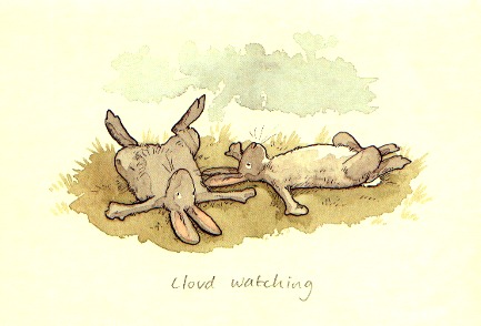
Can anyone out there relate to this????? Courtesy Anita Jeram |
|||
 |
Courtesy Sunday Herald Sun |
Today's Clothing Index: Stay inside by the fire.
Courtesy The Sunday Age - 24/8/97 |
|
| Bugger off ad nauseum The Advertising Standards Board has dismissed complaints against three popular ads - the Toyota ute-owning farmer who says "bugger" when things go wrong; the one where the hospital patient has had his jaw enlarged so that he can consume more chips; and the copulating snails who help sell mineral water. The bugger ad is not degrading to rural people and does not imply cruelty to animals. Use of the word "bugger" is innocuous and widely used in the community, the ASB sages decided. The thin chips as is "contextual humour" and does not make fun of people with jaw abnormalities. And little children are not likely to ask awkward questions about what the snails are up to. The complainants were not asked to get a life. Courtesy - Weekend Australian May 22-23, 1999 |
|||
| Faux
pas, bon mots and freudian slips..... Excerpts from Roger Edward's compilation of "colorful" (sic) text products from the NWS in the States...... *********************************************************************************************************************** ANOTHER QUIET MORNING IN THE MET WASTELAND AFTERNOON HEAT INDEX VALUES FROM 105 TO 1125 DEGREES EXPECTED..... THE (that was the whole product - - just the word THE) SUNNY SKY AND LIGHT WIND MAKES FOR A GOOD AFTERNOON TO RAKE LEAVES OR WHATEVER. THE OBSERVER HAS LOCKED HIMSELF OUT OF THE OFFICE AND CANNOT LOCATE A KEY. OBSERVATIONS WILL BE RESUMED AS SOON AS THE OFFICE IS OPENED. DISC: IT'S 9.30PM...DO YOU KNOW WHERE YOUR CAR IS? WELL...FCST A FLD YESTERDAY AND IT WAS DRY...FCST NO SNOW LAST NIGHT AND IT SNOWED...SO IF YOU IGNORE THIS DISCUSSION AND TRASH IT I'LL UNDERSTAND. ONE HUMONGOUS UGLY THUNDERSTORM WITH CONTUS LTG 7MI E MOVG S. CAN SEE THE HAIL IN IT FROM HERE. AMERICA IS A GREAT COUNTRY. BUT ANY CLAIMS TO ALTERING THE MOTIONS OF CELESTIAL BODIES IS A BIT TOO MUCH. EVEN ATMOSPHERIC PHENOMENA IS BEYOND OUR CONTROL...WHICH IS WHY THE WEATHER SERVICE WILL CONTINUE TO BUST FORECASTS FROM TIME TO TIME. USING LATEST FCST TECHNIQUES WE CALCULATE THE BACK EDGE OF THE CLDS IS MOVG SE AT EXACTLY ONE ERASER-HEAD PER 5 1/2 HRS. SKYWARN OBSERVER IN THE TOWN OF RIPLEY MEASURED HAIL DENSITY AT 86 PIECES PER SQUARE FOOT.
|
|||
| **'The
Cloud'** (the saga continues....) There have been a number of sightings of the cloud during the past 12 months, with the most recent showing 'The Cloud' being towed back home ........
|
|||
| Submitted by Chas Osborn (N Victoria)
...and to top it all off...... with thanks to the Weatherzone members for finding this
|
|||
| Not-so-seriously updated 11th July 2004 - J ONeill | |||