| Day 19: 10th May, 2010: The Cherokee - Medford - Braman - Arkansas City Tornadic
Supercell Chase I have a question for stormchasers....and I will take any advice...how the F#%@ do you chase a tornado rattling off at 100kmh??? In fact, to put that into perspective, this storm today was clocked at close to 140kmh in its motion at times....!!! It was a long tracked supercell, and we measured the damage track around 140km long...so to measure up how we felt after the event, I would liken it to chasing in an F111 along a 140km air strip - unfortunately we were the ones doing all the wiggling, dashing north and south to maintain our view. We started the day in Watonga which appears to have become a bit of a return trip for us. Relatively cheap motel, clean and spacious. It was foggy and drizzling and the temperature was in the high 50's (15C). Our destination / target area was Medford. A warm front was lifting up through northern Oklahoma - behind it was deep tropical Gulf air and temperature jumps of 10F. We continued north to Enid in fog and drizzle, had coffee and donuts at Medford late morning. The afternoon prognosis was for a dryline to advance through Oklahoma connected to a triple point in western Kansas. The southerly Gulf air was expected to accelerate across Oklahoma ahead of the dryline...the prognosis was correct! We dribbled west to Cherokee looking for clear air. With the warm front now moving into Kansas, we could feel the moisture and heat increase. We soon found clear skies near Cherokee where we stopped for lunch. In the time that we had spent in the gas station (approx 10 minutes), we emerged to find a distant congesting Cu had flared forward and developed into a storm. Being somewhat impatient, rather than wait, we drove southwest under an increasingly expanding anvil. After 30 minutes of so we encountered the main updraft base which was strongly developed on the southwest corner of the rain core. This portion of the storm was part of a right split...the left split section was dissipating to the north. There was no shortage of ground lightning - the storm at this point was pulsy. Individual maturing cells were being dragged rapidly northeast by upper shear. The updraft base occasionally rotated but the storm was struggling at this stage. We followed the storm northeast to Cherokee where someone flipped the switch!! and we had what could be regarded as an instant supercell! As we approached the outskirts of Cherokee we came across lots of other chasers.. American chasers are very cordial and operate safely on the roads, although you virtually never have time to say 'G'day' - everyone is doing their own thing...As we approached Cherokee we noticed white blobs on the grass, and the tornado sirens screaming..we pull over to photograph the retreating supercell and pick up golfball hailstones. We are fascinated by their shapes - jagged, kidney and golfball shapes - mainly measuring 3 - 5cm. The Medford supercell was racing northeast and we decided to join it. We were distracted again though in the middle of Cherokee where we noticed white lumps the size of oranges and cricket balls, we were out again photographing and collecting all the big ones...some measuring over 9cm!! The jagged ones looked best - this supercell meant business! We head north out of Cherokee leaving behind smashed cars and stunned residents. We could see now, way off to the east, the base of the supercell and we raced east towards Medford. It seemed that we are driving at unmentionable speeds and we still couldn't catch this monster.... After about 15 or 20 miles we notice some flashing lights..there was a car on the side of the road with all its windows smashed and white baseballs (giant hailstones!) strewn across the highway. Then we come across a whole line of telegraph poles snapped clean off, all pointing to the north. A mile further east, telegraph poles are snapped off and pointing south...the vortex of this supercell is big!! We continue east to Medford with the tornadic supercell continuing to rapidly recede to the northeast. The tornado itself passed about 9 miles north of Medford making for Braman. Radar showed a stupendous almost occluding hook. Prior to the I-35 we encounter 85 - 90kmh southerlies feeding into the storm. To our north was just a black inky featureless sky. We finally make it to the I-35 and head north. Near Braman, we come across mayhem and chaos...the rain wrapped monster has crossed the highway taking out 6 semi trailers and a number of cars. They had no chance in this rainwrapped tornado! We are cautious and hang back slightly.....the tornado had only crossed the road minutes before us and it was already way off to the northeast. We finally spot the vortex and start videoing.....but it's difficult on the interstate with so many emergency vehicles appearing and traffic stopped everywhere. We finally head east towards Arkansas City and the tornado beats us there by 5 minutes! Ark City is a sizeable town, and fortunately, the tornado skirts the northern fringes of the city, with at least 1 house demolished. We head east on H-166 but are turned back by a roadblock and debris...we are forced north to Winfield where we again turn east, but the storm is spent. After a few miles we head south on a side road (H-15)....we note a new storm developing near Ponca City and we finally reach H-166 and pace its northern flank towards the east. There is tremendous convection along its outflow boundary and we are caught in a downburst. Strong pulses along the outflow are generating their own funnels and weak tornadoes. Everything appears chaotic and spinning...we drive east for another half hour and finally encounter the main updraft core of the Ponca City supercell. We see a few more funnels, lots of chasers and one roping out tornado......we finally arrive at Independence to watch the day's storms disappear to the east.
|
|
 The early morning fog and drizzle is deceptive...sure nothing can come from this..... |
 We took the 2 for $2.22 tornado deal...boy, did that pay off!! |
 You can see country towns for miles by the water tower sticking out of the ground. Medford was our target today |
 Initial pulse of what was to become Medford's tornadic supercell, taken SW of Cherokee |
 Medford supercell passing to the NE of Cherokee |
 Medford supercell approaching Cherokee from the SW |
 Structure of NW side of the rapidly spreading anvil, near Cherokee looking SW |
 Structure of NW side of the rapidly spreading anvil, near Cherokee looking SW |
 Structure of NW side of the rapidly spreading anvil, near Cherokee looking SW |
 Structure of NW side of the rapidly spreading anvil, near Cherokee looking SW |
 The business end and main updraft of the pre-tornadic stage near Cherokee, looking SW |
 The updraft base was already showing sporadic rotation |
 A feature of the Medford supercell was the abundance of funnels - some became detached |
 The main updraft core separated from the rainshaft and was shifting to the right |
 The weakly rotating updraft core continues to break away from the rainshaft. Upper shear was dragging the main precipitation core NE |
 The western flank of the main updraft was showing sporadic rotation, near Cherokee |
 Another funnel detaches from the updraft base and spins madly, Cherokee |
 Occasionally the main inflow alignment became linear. |
 The broadening flanking line NE of Cherokee - the storm was producing huge hailstones at this stage |
 The remarkable backshearing anvil on the backside of the supercell, Cherokee |
 Near Cherokee |
 Our first stop SW of Cherokee with our booty of 4 - 5cm hailstones |
 Structure of storm moving NE of Cherokee towards Medford |
 Structure of storm moving NE of Cherokee towards Medford |
 Structure of storm moving NE of Cherokee towards Medford |
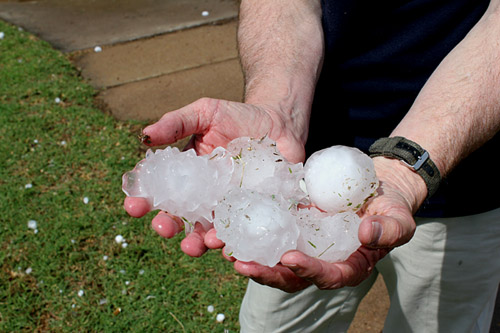 If we thought the previous image of hailstones was extraordinary,we were totally astonished at the size of hail in Cherokee itself - measuring up to 9cm - a mix of jagged, cricket ball and kidney shaped stones |
 The main updraft core and wallcloud was huge! The storm became rapidly tornadic north of Cherokee |
 This was the main wallcloud area between Cherokee and Medford |
 Another view of the rapidly receding Medford wallcloud - the wallcloud kept generating shortlived vortices and funnels |
 A feature of the Medford tornadic supercell was the number of funnels it produced. We deduced that the wallcloud was a very large tornadic feature and had a lifespan of more than 3 hours. |
 Between Cherokee and Medford we came across a section of road more than 2 miles long with toppled powerpoles. This is where the core of the supercell passed over. |
 The Medford supercell was moving in excess of 100kmh - we had great difficulty keeping up with it....barely 5 minutes after the tornado had tracked across I-35, we came across 6 unfortunate semi trailers that had been tossed from the highway. For most of its life the Medford tornado was rainwrapped and very dangerous. |
 The main damage along I-35 occurred over a length of 1.5miles (3km) |
 This is a series of video captures showing the tornado receding rapidly to the NE. The storm was in a weakening phase. |
 |
 |
 |
 |
 |
 |
 Near the end of its life, a large rotating area remained. |
 House destroyed, north of Arkansas City |
 The tornado passed along the northern side of Arkansas City. |
 After the Medford supercell disappeared into eastern Kansas, we tagged onto another supercell northeast of Ponca City |
 As we travelled along its northern edge, its outflow was generating very potent updrafts. |
 The main updraft alignment of the Ponca City supercell |
 We were stunned to see a rotating tail poke out from a strong updraft on the NW side of the supercell |
 A very close encounter with a large funnel! |
 It was a weird scene - just about everything was rolling or rotating.... |
 A weak tornado ropes out near Independence - the Ponca City Supercell decayed rapidly from this time. |
| Stay tuned for tomorrow's episode... | |