| Day
21: 12th May, 2010: The Burlington, Oklahoma Supercell All the motels in Watonga are booked out on the 11th, we have just arrived after our marathon chase of the Woodward LP supercell - the motel owner tells us she has a B & B located in the town centre....it's one of those old fashioned American, almost saloon type buildings in downtown Watonga. We are pleasantly surprised by the standard of the room - it has been done up to a high level, but we are not as enthusiastic when we discover the room was used by an old time dentist - and all of her old instruments are paraded about the room or hanging off the wall - some of them look like safecracking devices. The cost of accommodation however, includes breakfast and after a pleasant overnight sleep, we are served full American breakfasts which are hashbrowns, eggs (sunny side up), bacon, fried bread and whatever else you would like with it - it was absolutely fantastic!! We load up our Dodge Charger and are immediately hit by the clammy warm mist of another Gulf airmass. Today our destination is Cherokee (again), northern Oklahoma. Storms are expected to erupt ahead of an approaching cold front from Kansas connected to a small low in western Kansas. We are soon on our way through the pleasant country of western Oklahoma...as we head north, the low gunky, cloud deck breaks and temperatures are approaching the low 80's and humidity is near70%. A couple of hours later we are parked in a wildlife observation point north of Cherokee...large Cu passing by, but not doing much..they struggle against a midlevel glaciating cloud deck. By mid afternoon, the first echoes appear near Alva, and we head north towards Burlington and Kiowa, almost on the Kansas border. As usual, the American storms, once started, erupt into a line of bludgeoning supercells. The only drawback today is the 'Texas haze'! Burlington is a hamlet near the Kansas border, a few houses and a great hamburger store at the local gas station. Don't be put off by the dithering old lady who cooks them...her cooking is the best we've tasted when it comes to hamburgers. With our stomachs aside, we move north to intersect the now well developed storms to our northwest. We pull over on a side road (county road) between Burlington and Kiowa....a large storm is barely 2 miles (3.5kms) to our west and is already putting down a wallcloud. The countryside around here is all wheat growing and the crops are well advanced and they make good landscape photography with a photogenic storm in the background. We set up and watch. Within minutes, the wallcloud puts out a small funnel which spins wildly then disappears. A few minutes later, the wallcloud, still at work, drops a larger funnel and this looks promising...but the supercell is being undercut now by the cold front - the RFD has mixed with the frontal boundary and cold outflow races east behind the storm. The wallcloud dissipates... We drop south to meet another supercell moving northeast along the line, which rapidly develops another wallcloud which only sporadically spins. We photograph another broad funnel..the setup with the Oklahoma wheatfields and the storm base looks brilliant! This funnel also fails..and the cold front has done its work again, and kills the low level circulation. We continue to observe the frontal line for the next hour or so, and then pull back east - it's already evening and the time has gone. We overnight at Ponca City and watch fantastic lightning and strong cells pass over through the night with hail and strong wind gusts in excess of 80kmh.
|
|
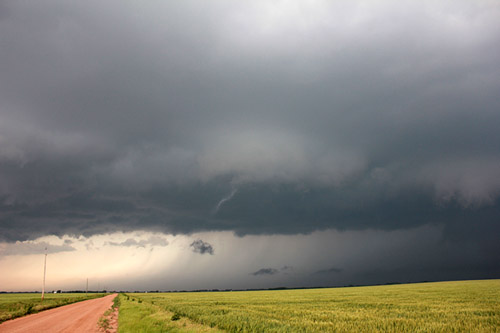
 The great base features emerge from the 'Texas haze' as we move closer to the storm. |
 We sit and watch the storm develop across the wheatfields of northern Oklahoma.
|
 Activity develops under the main updraft with a small wallcloud appearing. |
 Interesting lowerings and scud develop rapidly under the base - we suspect the RFD was interacting with the frontal boundary near here |
 Looking SW along the frontal line, towards the second supercell in the area |
 The first supercell gets its updraft base east of the frontal line, and for a short period, rotates and develops a weak funnel. |
 The funnel lasts only a few minutes and disappears. |
 The rainfoot and RFD are apparent here. |
 After the first wallcloud dissipates, a second wallcloud rapidly develops as the storm feeds on rich moisture on its southeastern flank.
|
 A larger funnel appears briefly, but is underrun by the coldfront and dissipates. |
 The amazing extent of the backshearing anvil. The storm tops were clocked at more than 50,000'!
|
 |
| Stay tuned for tomorrow's episode... | |