| Day
31: 22nd May: We overnight at Alliance Nebraska. Alliance is a busy
rail junction and there is an overwhelming scent of cattle feedlots in the air, the town
however is neat and surprisingly busy at 7am. Our plan today is to ride east then north
into South Dakota. Western Nebraska has a very interesting geological history, Alliance
sits near 4,000 feet and adjoins the high plains of Wyoming which is located near 50 miles
to the west - as you drive east from Alliance you soon enter the heartland of the
Sandhills, an area of the USA which is sparsely populated - other than the millions of
individual sand hills ranching and farming appear to be the main settlements, large
expanses of cattle properties prevail with some cropping along narrow valley alignments.
The Sandhills region is a reminder of the forces involved with the past ice age. The
Sandhills are presently covered with native grass but from time to time the climate
variations of the past 20,000 years has seen the sand exposed with little grass
cover. This morning as we drive east along Hwy 2 which straddles the main coal/freight railroad the weather is fine. The analysis shows a large amount of Gulf tropical moisture penetrating into eastern Nebraska and Sth Dakota, a frontal system is expected to push across Sth Dakota through the day, an area near Pierre Sth Dakota is our primary target. As we pass east along Hwy 2 we view the busy rail line with huge coal trains heading east many with 4 or 6 locomotives, it's a juxtaposition in regards to the so called 'carbon' reduction climate controls...the real world here in Nebraska shows little coalition with the climate boffins wanting to limit carbon production, even on the pathetic weather channel, adverts for the coal industries predominate ! and then are followed by outcries of well meaning interviewers calling for carbon reduction........We finally arrive at a small town of Mullen, one of several along Hwy 2. For the most part these towns appear suppressed and run down but Mullen has a clean and active main street...with a coffee house. We enter for a morning break and notice a cappuccino machine !.....Unfortunately the caretakers of the coffee shop are just that...the owner is out of town, the large fellow does not have a clue how to operate the Cappuccino machine...never mind we drink regular coffee and eat fresh cookies...we compliment him on his cooking but he spoils his skill by announcing that he just squeezed the mix out of a plastic bag. This is what we liked about 'small town America' the honesty of the people and their genuine desire to do their best....and where in Australia can you get coffee and cookies for $2.40 including Tax..... We leave Mullen behind and head north on Hwy 51 which passes through deep Sandhills country and finally arrive at Valentine....A number of chasers are already here and after fuel we continue north soon arriving in South Dakota......Central South Dakota is so different from the Sandhills - it's undulating with extensive grasslands...Cropping and cattle prevail. Already the temperature has reached the mid 80's F...and Dew points are in the low 60'sF, there is little cloud apart from patchy cirrus to the west. South of Pierre we see the first cumulus field. Pierre is a sizeable city and the massive Missouri river passes through the settlement but we have no time for a city stop and continue north getting closer to the area of convection. It's mid afternoon by the time we reach an area southwest of Gettysburg. We watch the struggling cumulus do not much, the lower level cap is reasonably strong. We dribble north to just southwest of Bowdle (Hwy 12) and sit. As if by magic the first large cumulus appears then sends its fast moving updraft to glaciate. The anvil spreads under the tropopause leaving a twisted narrow updraft.....Then all hell breaks out several more updrafts combine and within 30 minutes the single updraft has metamorphed into supercell with a rotating wall cloud....'The Cap has broken'. We follow the ever increasing supercell northeast but are blocked by its rain core... as we drive east along Hwy 12 west of Bowdle, incredibly the radar returns a brilliant hook shape. We hold back on the west side of the hook, our only view east is of a black mass with no features. finally the hook passes north of Hwy 12 and we pursue... near Bowdle we emerge from the southern quadrant of the rain wrap to see a magnification trunk tornado to our north, the tornado is moving west on the northern quadrant of the now large meso, then dissipates !. We drive north along a side farm road (sealed) and watch the meso for more activity, from this position we can see the entire cyclonic rotation of the meso now about 3 or 5 miles wide. A broad and fast rotating area appears on the west quadrant. A large weakish 'egg beater' is bearing down on our location with several suction vortices. We video and photograph...the tornado has done a loop the loop and is going to pass just a few hundred metres to our north...several research vehicles in front of us suddenly do a U turn and speed away...the winds increase from the southwest to at least 140kph and the huge tornado passes about 200 or 300 meters to our north, we are pelted with torrential rain and hail/mud, our trusty Dodge Charger shudders and we also escape south only to be caught in a weak suction vortex that literally elevates the car......we turn west on Hwy 12 and stop behind a Semi, then a screaming north wind suddenly starts on the western quadrant of the meso - the pressure gradient must be huge, the truck in front of us was visibly being lifted on its northern side....The wind is so strong it blows the road surface clean of water !....The western side of the meso is a mass of twisting horizontal fractus racing into the core of the mesocyclone....what a fantastic experience. Soon the winds subside and we follow the meso and wall cloud area east along Hwy 12 but the Bowdle tornado has done its work, as evening darkness increases the storm become a linear affair but still packs a punch with 60mph outflow gusts mixed with small to medium hail (pea to one inch). We drive ahead of the outflow boundary and finally reach Aberdeen.....From our top floor we watch the outflow storm alignment pass over with one inch hail and strobe lightning.....Again exhausted, the night is a mix of vivid dreams and ' retina recall' of the previous day.....such is a storm chasers life.....
|
|
 The endless storm roads of South Dakota |
 South Dakota is great chase country |
 There are many abandoned farmhouses |
 Concrete roads are fine until they crack - simple remedy, fill the cracks with bitumen, near Murdo... |
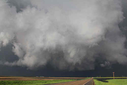
 Who could believe this could turn into a tornadic supercell in an hour. Cumulus field north of Pierre |
 Southwest of Bowdle, the first storm erupts |
 When the cumulus tops go, the speed of ascent is breathtaking! |
 With the cap broken, the updraft powers to near 40,000' in minutes. |
 As one updraft develops, many more appear like magic. |
 Even in this early stage, the first updraft is rotating. |
 This is the tail end Charlie area. Two pulses are starting to merge
|
The primary cell develops an inflow tail. |
 The two cells have now merged. |
 The wall cloud area is already wrapping rain |
 Rain wraps form the left into an increasingly stronger rotating wall. |
 The first funnel appears near Lowry. |
 This is the SW infeed flanking line. |
 Amazingly, the flanking line is dwarfed by the supercell backshearing anvil which was powering above 55,000'. |
 The pointed lowering almost reaching the ground was subsidence and powering in towards the meso |
 The meso and wall area are buried under the main updraft. Near Bowdle. |
|
Closeup of rapidly subsiding prong being drawn into the meso. Suspect an RFD here. |
 The SW edge of the storm near Bowdle, looking east. |
 A tail rotates around the west side of the meso which is hidden beyond the rainbow. |
 The Dominator races towards its destiny (the inside of a tornado) |
 As we drive closer to the meso, the tornado is viewed partially rainwrapped (Bowdle) |
 A closer view of the trunk. |

|
 A tornado recedes up into the meso. |
 A few minutes later, a large tornado is rain wrapped and appears to be doing a loop - the - loop - it is now moving SW on the west side of the mesocyclone. We are located on the SE quadrant. |
 The broad eggbeater approaches us from the northwest. |
 Here the tornado is marked by multiple vortices on the ground. |
 Several of the vortices intensify rapidly |
 Tornado research vehicles flee as the tornado bears down! |
 The tornado passes barely 300m in front of us. |
 The west side of the wallcloud was a mass of horizontally rotating cloud elements. We were blasted with windgusts approaching 140kmh! |
 The wall area recedes towards the NE as the storm weakens. |
 Later, the storm evolves into a linear feature generating 50 or 60mph straight line gusts. |
 Our final view of the HP supercell near Aberdeen. |
| Stay tuned for tomorrow's episode... | |

