| Day
34: Shawnee, OK to Guthrie, OK Every stormchaser has his horror stories of near misses....ours was on the 21st when we followed a 'sucker cell' in northern Oklahoma. The definition of a 'sucker cell' - the storm does all the right things..rock solid rainfree base, looks good, but you spot another cell 60 miles south....we decide to follow the sucker cell developing overhead....we follow for an hour or so, and just as we decide to give up the chase with the sucker cell meandering about doing not much at all, the cell spotted 60 miles to the south drops a tornado!! So then we dash south only to find that this cell has weakened as well...but a new cell has developed on its southern quadrant, and this also becomes tornado warned! We arrive 20 minutes late as the storm is now collapsing. 2 tornadic supercells and 1 sucker cell defeats our day.... On the 22nd, we drive into southern Oklahoma. By later afternoon, this impressive looking storm 'on radar', is drifting northeast from Texas into southern Oklahoma at a steady 40 mph. This storm fits all the criteria of a supercell - tops to near 60,000', midlevel rotation, large hailstones and it appears to be in a good position for a reasonably long life. We drive into Sulphur Springs with a darkening sky and a spreading thick anvil with mammatus. We head west from Sulphur Springs looking for the flanking line...we don't find one. We drive through the western raincore hoping to find an inflow on its southern edge...nothing! Scratching our heads we try to figure out what this storm is doing...radar returns still show a strong storm! but there is virtually no surface interaction of significance. We do note however that there are strong updrafts in the middle levels, and we deduce that we have interacted with a 'mega sucker cell'! It appears the storm was high based on initiation in Texas and drifted into Oklahoma with only very marginal surface interaction. We waltz about for the next 2 hours watching updraft after updraft interfere with each other, and we head for Shawnee to overnight. On the morning of the 23rd, the prognosis looks reasonable for western Oklahoma....the dryline is set to advance east, but not too fast. Moisture is expected to return later in the day. We sit and watch at the intersection of Hway 51 and the I35 for a couple of hours, and we eventually decide to move west towards Hennessy and get closer to the dryline. Continuing west from Hennessy we arrive near OKeene - two cells have developed on the dryline, one to our SW and one to our NW. We choose the NW cell and drive north of OKeene along Hway 8. We can see a fairly solid rainfree base to our west, however it's high based, marginal moisture is available here near the dryline, but the midlevels are very unstable, and eroding updrafts are dropping funnels. Midlevel rotation is tagged on radar and a strong backshearing anvil gives the story away. Although scavenging for moisture, the mid and upper levels are returning strong energy potential. The rainfree base to our west is expanding and getting darker. We spot several more funnels attempting to reach groundward..... Strong cloud to surface lightning gets underway - a good sign! We head a little further west towards Fairview to watch the rainfree base area. All we need now is for the midlevel rotation to line up with the solid base area....and soon this happens. A larger funnel drops from the cloud base! A slender funnel drops earthward and we notice agitation on the ground! Contact!! The tornado swirls along the ground for about 3 minutes, providing a magnificent vista.... The funnel recedes into the cloud base...show over. We follow the storm for a half hour or so but it continues to weaken, and we head east. Storms are now grouping into large multicell complexes with strong outflow boundaries. We get trapped in the core of one cell dropping golfball hail - we escape south at Hennessy towards Kingfisher where we photograph a strong outflow guster heading SE. With most of the area affected by outflow, we decide to give the game away ad head for Guthrie, but the day is not finished with us yet.....moisture has been returning through the afternoon through central Oklahoma. North of Kingfisher we spot what appears to be a large wallcloud to our NW...we are trying to figure out how a wallcloud manages to sustain itself in cool outflow?! However one of these cells has become strongly developed and progresses to supercell status - it is feeding off slightly elevated warm moist air from the south - it is also ingesting relatively cool outflow air near the surface. We drive to the west of Kingfisher in poor light - we video and photograph the large rotating wall approaching the township..it appears to be dropping tendrils of vapour to the surface...the wall area is large and moving quickly southeast. Strong lightning accompanies the approach of the rotating wall cloud - we hear no sirens go off in Kingfisher and are puzzled - the locals appear concerned. As the wall area approaches our location we can see rapid spin motion in the base. We escape west but run into large hail - we turn and head east towards Guthrie. Fortunately for Kingfisher the wall collapses just west of town. We hear a few reports of chaser vehicles damaged by large hail...and we finally arrive at Guthrie with frequent lightning and heavy rain.
|
|
| Photos: 21st May 2011 | |
 |
 |
 |
 |
 |
 |
 |
|
 |
 |
 |
 |
 |
 |
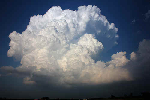
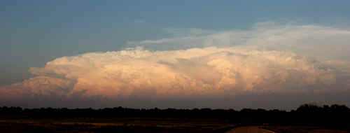
| Photos: 22nd May 2011 | |
 |
 |
 |
 |
 |
 |
 |
 |
 |
 |
| Photos: 23rd May 2011 | |
 Passing a DOW - and our tornado snowdome mascot |
 First weak funnel N of OKeene |
 Brilliant backshearing updraft near Fairview |
 Bulging updrafts near the dryline |
 Storm intensifying near the dryline (Fairview) |
 Developing rainfree base, Fairview |
 Rainfree base and respectable rainfoot, Fairview |
 Storm spotter in position north of OKeene |
 Rail/hail core and solid rainfree base |
 The convergence area under the rainfree base was marked by a great deal of haze |
 The early stages of the tornadic phase were marked by a succession of high based funnels |

|
 Occasionally a funnel would drop halfway to the ground but then fail |
 |
 First signs of rotation and a funnel appear beneath the rain free base |
 Funnel inches its way groundward |
 Contact! |
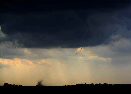 Near the dryline humidity was relatively low. Although the condensation funnel doesn't appear to reach the ground, it is most definitely in contact. |

|
 The tornado was in contact with the ground for maybe 3 - 4 minutes then weakened |
 The tornado funnel shears away from its ground contact |
|
 |
 In the vicinity of the dryline, new convection continually evolves |
 By early evening, some storms have become outflow dominant |
 |
 Hidden amongst the chaos is a backshearing anvil |
 Later in the evening with fading light, multicell groups combine to produce strong storms |
 Surf's up!! |
 Gust front, north of Kingfisher |
 Gust front near Kingfisher. Golf ball hail was falling in the core of this storm |
 By late evening an extraordinary supercell evolves., |
 The rotating wallcloud approaches Kingfisher late evening. |
 The wall occasionally produces brief vortices extending to the ground. |
| Stay tuned for tomorrow's episode... | |