| Day
10: Malvern, AR to Marshall, TX - The Mabank/Kemp tornado, Texas Barely recovered from our excitement of the day before, our target area today is North Texas east of Dallas. However, we'd encountered a problem with the vehicle - our front right hand tyre was deflating - behind the hotel was a tyre supply company. As we parked nose in to the reception, we noticed a lot of men milling around inside the workshop. 2 of the larger fellows were aiding a very old gentleman to the front roller door of the workshop. (the old gentleman turned out to be the owner of the business, and all dealings were done through him). As I got out to explain outrpredicament, a large muscly guy became bugeyed! "What accent is that?": he calls..."bloody Aussies, mate!"..."goddamn!!" he squawked..."I've never met any of those..." and when we explained what we were doing in America, he gasped in disbelief. We even showed him the hail dents on our Chevy Traverse.... After a few minutes of frivolities and introductions, he still couldn't get our mind on our predicament, he was more interested in hearing about Australia which included an unhealthy interest in giant crocodiles and a host of other poisonous things that inhabit the Australian outback. Our tyre had taken a stone, right through the wall, what was going to be a $20 fixit turned into a $200 new tyre!! We also needed to have an oil change which is another thing that you are responsible for when you rent a vehicle for a long time.....we found that Wal-Mart has a drivein oil change section...you park your car in a conveyor belt setup and a bunch of grease monkeys attack it! 20 minutes later you drive away - cost? $25.04!!!!! Try getting a full service for that kind of money in Australia! Back to the chase....we are now heading SW towards Dallas on I30....it's foggy and drizzling. The fog and drizzle linger on virtually 2/3 of the way into Texas....A large storm has developed to the south of Dallas, and we are reluctant to chase through such a mega metropolis so we hold back and wait for the storm to progress farther east of the metroplex. We vector the storm motion and head for the town of Kemp. Road systems here are reasonable but there is a big reservoir running north-south west of Kemp and we have to be careful with our road options.The radar is displaying a curious double meso...we think this is a glitch as we spot a wallcloud to our SW well clear of rain. This turns out to be a good option...except the area around the wall may have been rain clear, but it wasn't clear of hail! We watch the wall area pass onto the lake/reservoir...we head south to cross a large bridge linking the west and east bank of the lake...it's here we notice that the spinning wallcloud is tightening and an almost perfect funnel pokes out from the middle!! This happens when we are right on the narrow bridge...we can't stop...but we take the opportunity to photograph as rapidly as we can. The funnel touches down over the lake and we can see water and spray flying everywhere....ascending the trunk...was this one of those occasions where some farmer 20 miles away gets a whole load of fish dropped in his backyard?? The waterspout goes ashore and becomes a tornado! We are trapped in a residential area for a few minutes before escaping north where we photograph the near perfect tornadic shape before it ropes out. Immediately, we pick up a second supercell to our west and for the second time, we follow our original route to the lake.This storm appears larger than the previous tornadic event and it's sparking lightning all over the place. We carefully ride through the precipitation core and then view the ungodly sight of a low level jet flying into the mesocyclone....the alignment of flying fractus and cumulus appeared to be a converging point of the RFD and warm conveyor belt. As this inflow jet encountered the mesocyclone it abruptly wrapped around to produce a remarkable wallcloud. It was rapidly rain wrapping. We follow the rotating wall across the same bridge into Gun Barrel, but now the wall area is completely rain wrapped and very dangerous as it passes just north of the town. The town was plunged into near darkness and sirens were blaring! Our radar was becoming briefly unreliable as we lost communication and we take a southerly road option to get away from the rain wrap area. Further south, we parallel the rain wrapping meso with limited views. Soon this storm complex becomes a linear feature as the RFD occluded the meso, and we ride the shelf cloud east for the next hour and a half. Our chase day is over..and we head for Marshall ,Texas for an overnight stay.
|
|
 Storm chaser blockage, I30 |
 We discovered that Texarkana is in 2 states!! |
 Road building gone mad, Texarkana |
 The I30 is a major trucking highway |
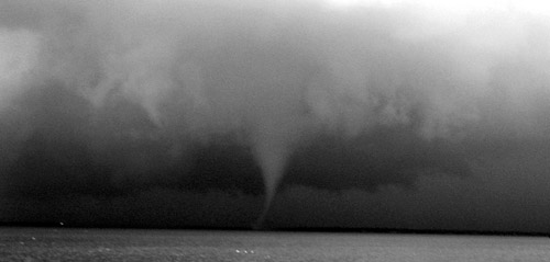
 Evolution of a tornado, initially as a rotating wallcloud, SW of Kemp |
 |
 |
 Touchdown!! Tornado touches down first in a lake, technically becomes a waterspout |
 |
 The waterspout passes onto land, so technically becomes a tornado (the last thing we would expect is to see a waterspout in the middle of Texas!!) |
 |
 |
 |
 |
 Over land, the tornado takes a classic shape - in these images it is becoming sheared over |
 |
 Tornado
finally ropes out after a life span of approx 20 minutes, E of Kemp Tornado
finally ropes out after a life span of approx 20 minutes, E of Kemp |
 About an hour later we chase a new supercell W of Gun Barrel |
 Low level inflow jet speeding towards the mesocyclone W of Gun Barrel |
 The mega inflow alignment was mindblowing!
|
 The inflow was associated with the RFD which paralleled its NW side and here is wrapping into the mesocyclone. |
 The rapidly rotating wallcloud moving W of Gun Barrel |
 Rotating wallcloud structure, W of Gun Barrel |
 |
 |
 We allowed the wallcloud pass by and followed it in from a westerly direction. The rain wrap can be seen cutting in on the right. |
 We suspected this customer had been waiting 20 years for service...so we passed on by.. |
|
 |
|
| Stay tuned for tomorrow's episode... | |