| A Description and Alternative
Hypothesis for the Sydney Hailstorm - 14th April 1999
Clyve Herbert (ASWA - Victoria) |
|
|
|
| There were
several interesting features about the Sydney April 14 1999 storm that struck me as
unusual. But to decipher the remarkable puzzle and pick through the possible or probable
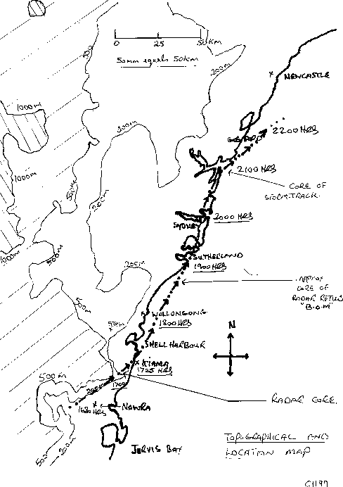
causes was a journey into new territory, and this started the previous day (13/4/99) when
unexpected thunderstorm activity developed over southern NSW south of Canberra. (Radar Loop) This
unanalysed activity took my interest as it may have meant that an undetected upper feature
may have been present and was reacting to surface heating and local topography. This area
of upper instability, possibly reflecting a cold pool, appears to have moved north
eastward towards the south central NSW coast the following day. Meanwhile, a weak cold
front was advancing northward along the southeast coast of NSW reaching a point just south
of Nowra by mid afternoon (1502hrs)
of the 14th April.
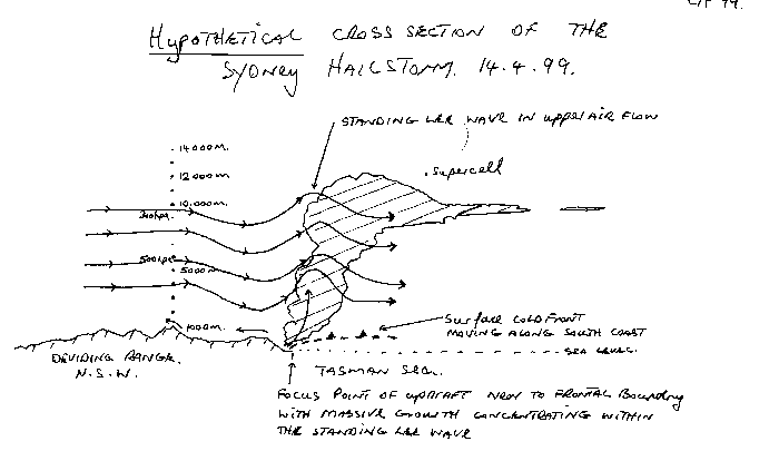
It has been established that the storm reached supercell status for most of its existence producing phenomenal hail and what has now become Australia's most costly natural disaster. To describe some of the interesting features of this storm probably takes us into a hypothetical discussion on why the storm behaved the way it did.
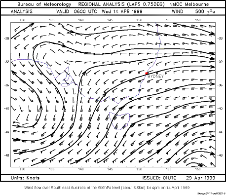
Wind Pattern over southeast
Australia at the 500hPa level (approx 5.5km) for 4pm EST 14 April 1999.
|
|
| To summarise this hypothesis: it appears that the weak surface cold front pushing northward along the south coast may have interacted with a standing lee wave east of the Great Dividing Range with maximum updraft occurring within this lee wave location just off the south coast of NSW. The focus point of the main updraft continued to move northward near to the surface cold front more or less under the upper lee wave feature present at between 600 and 300hpa. This developmental process allowed the storm to move at a relatively sharp angle to the left of the middle & upper geostrophic flow. Other contributing factors may have been a cold pool at between 400 & 250 hpa which may have moved northeastward from southern NSW the previous day. |
|
| Updraft strength & hail size relationship The actual concept of hail generation surprisingly is one of the least understood aspects of the storm environment. The mind boggles at the thought of how strong an updraft is required to suspend a single hailstone as large as 9cm; but not just 1 hailstone, but millions of these iceballs are suspended and moved around the updraft core in a severe supercell hail-generating storm. The updraft core or updraft jet in a thunderstorm must at least match or exceed the terminal velocity of each hailstone. Naturally, the larger the ice stone the stronger the updraft required. Other aspects to consider are that hailstones are not always spherical, but can take on a multitude of shapes thus altering their drag and air resistance status. Maximum updrafts required for lifting very large hail through the main updraft core probably would exceed 50 metres per second (mps) and possibly reach 60mps or more. Such an updraft intensity is generated by the actual storm environmental potential, but an aspect not discussed is the mass vapour conversion (MVC) - that is the conversion of water vapour to solid ice which may assist in the provision of heat exchange and the drying of the middle and upper parts of the updraft core allowing further enhancement of the updraft jet in certain situations. The Sydney hailstorm supercell is known to have generated 6-9cm stones and probably larger examples greater than 9cm may have developed, thus we may deduce updraft core speed of greater than 50mps and possibly greater than 60mps occurred. Another interesting aspect of hail, is when hailstones fall through the FZL (freezing level) towards the surface layers, the outer parts of the stone start melting. This induces evaporation which results in a short period of additional cooling and allowing the stone to refreeze which may lower the local FZL to below the environmental FZL and additionally raising the storm environmental lapse rate.
Clyve Herbert - ASWA - Victoria June 1999
|
|
| Acknowledgements: | |
| Bureau of Meteorology | radar images |
| 300hPa analysis | |
| 500hPa analysis | |
| CSIRO Marine Research | NOAA12 thermal images |
| James Cook University / Robin Land | IR Satellite Loop |