| Day
27: 18th May: Overall, most of the motels/hotels we stay are at are of high
quality...there are lots to choose from - Holiday Inn, Comfort Inn, Super 8, Best Western,
AmericaInn, Sleep Inn, and there are many other smaller chain accommodation
companies....America is geared for the road system, accommodation is easy to find most of
the time. Occasionally though, we come across a location or you end up at a location that
is isolated. Such was the case yesterday when we arrived at Tatum, SE New Mexico. There
are 3 motels in this town, 2 of which are closed. From the outside, the motel looks bright
and shiny, but when we register we are a bit concerned about the 10 year old boy who is
'running' the place. As the old saying goes, 'beggars can't be choosers', so we chose to
stay the night. The room we have been allocated has been upgraded, but the upgrade appears
to consist of material thrown out from the 2 closed motels in the town! The new carpet is
actually a hotchpotch of different types of carpet sewn together. The motel has also
received an electrical upgrade, however the renovators have found a new and cheap way of
rewiring...they have simply tacked them to the walls...all of the old switches are left in
place, and new switches placed next to them. The room is relatively small and the
southerly wind that is blowing outside is whistling through a window crack! There is a
separate room near the front door that contains a bucket and a broom...we don't know what
it's for. In the bathroom, there is a distinctive smell of sulphur and we discover a
stronger version when we turn the taps on. On the positive side, the TV has over 500
channels!!! which would be a channel surfers delight......We settle down to an
uncomfortable night. We depart Tatum early in thick fog. The dryline is still to our west and straddles the Texas - New Mexico border. Our target today is the northern Texas Panhandle where the interacting dryline is expected to kick off isolated supercells. Pretty soon we are into Texas and the fog is gone....we stop at Brownsfield to take care of some postage. We've discovered some oddities about US Post Offices. Occasionally they are out of town or tucked away in a back street...in Brownsfield, it sits behind a large carpark away from the main drag. There is no impatience in a postoffice queue here in America...everything is orderly. We finish our postal business, and head north for some serious weather chasing. We eventually arrive near Dumas, and it's later afternoon and nothing has happened....only a few ragged cumulus appear under a patchy cirrus sky. We push further west to Hartley, where we find a rest area. It's already after 4pm, the southerly is pumping and moisture is high - and we wait. Chaser advection is working - within minutes, Dean and Willoughby from Australia arrive and we spend a pleasant half hour chatting and joking. In the meantime, an alignment of Cu to the southwest darkens its bases, and the first towers erupt and radar shows a yellow splotch. As far as we can see, it's the only echo of note in Texas. A few pleasant 'goodbye and good luck''s and we're off! We end up finding a farm road WNW of Hartley. Our objective is to find the flanking line of the storms. It is still a relatively weak multicell - its flanking line is unusual - poking out to the NW. We park on a rise and watch the cell pass a little to our south. Over the next half hour the flanking line shifts its position from the NW to the SW and the cell cranks! Its huge updraft core is starting to backshear, and its base features are looking better all the time. It is drawing its feed from the SW and developing a wallcloud. The wallcloud occasionally rotates...but struggles. The cell has now developed a continuous grumble with frequent lightning flashes. We drive closer to Hartley and watch the wallcloud gain control. We stop near a feedlot where cows are bellowing...there's been a flash flood here! Then we notice 1" hail sporadically spread through the grass. The wall cloud lowers, but is being progressively wrapped in precipitation, and then within seconds, a funnel appears! Over the next 5 minutes or so the funnel grows to be a tornado and then recedes to disappear in a rainwrap. We follow the cell east to Dumas - we come across hail swaths with some stones larger than golfballs - emergency vehicles are passing us, heading west. As we approach Dumas, we pull over to watch the wall region of the storm - our vision to the east is blocked by mist, so the wall is only momentarily appearing. We drive a little further east to see an unbelievable sight of mist on the ground rotating around the main wall area. The meso and wallcloud pass very close to Dumas and sirens are blaring and we video a complex funnel interacting with the mist. We allow the storm to clear Dumas and we follow east on the Dumas - Stinnett Road. Vortex 2 vehicles are in the area, and we photograph a DOW racing east. The supercell has developed a massive flanking line and is undoubtedly a dominator! We are driving under the flanking line in and out of cold and warm air surges - the underside is chaotic! with lowerings and rotation appearing all over the place. The main wall is further east but appears to be weakening, but still manages to put out 2 more funnels. We are startled by the sudden appearance of rotating scud to our west which rapidly thickens. A funnel appears and makes ground contact. The flanking line is building a new updraft core, and soon become the primary area of new rotation. We follow the new wallcloud east, we suspect this beast has a tornado hidden inside the drizzly wrapped meso....an outer ring appears, almost like a skirt and rotates around the meso core. The storm approaches Stinnett which is on full alert with sirens screaming, but the storm seems to be changing its appearance, and is becoming more of an HP supercell with a strong feed on its southwest quadrant. There are far too many chasers at Stinnett, not to mention deployed Vortex vehicles..it is far too crowded for our liking. It is getting dark and we need to get to overnight accommodation in Pampa, TX. On the way we occasionally stop and photograph the unbelievable structure of this supercell.
|
|
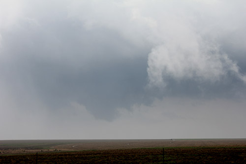
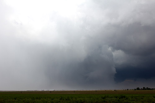
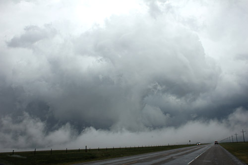
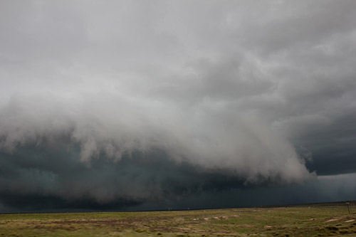
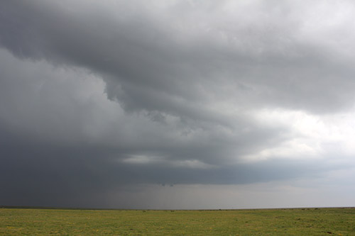 The only cell to develop in the west Texas panhandle was near Hartley in the late afternoon |
 Initially the cell developed several infeed lines in its multicell stage, then rapidly concentrated its southern flanking line with became the primary updraft core area.An attempted wallcloud develops here. |
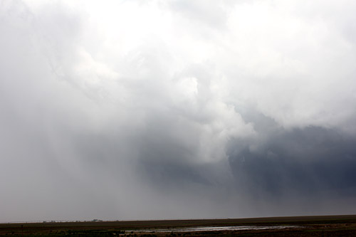
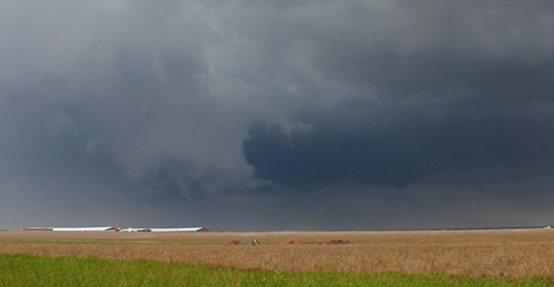
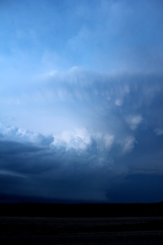
 This is an interesting image - rain can be seen starting to wrap around the wall and funnel area near Hartley...looking SW |
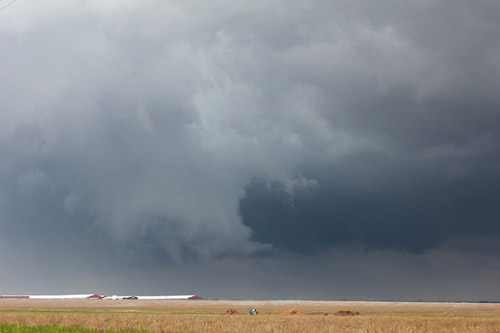
 Rain continues to be drawn into the rotating meso obliterating the view of the funnel (near Hartley) |
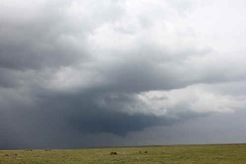
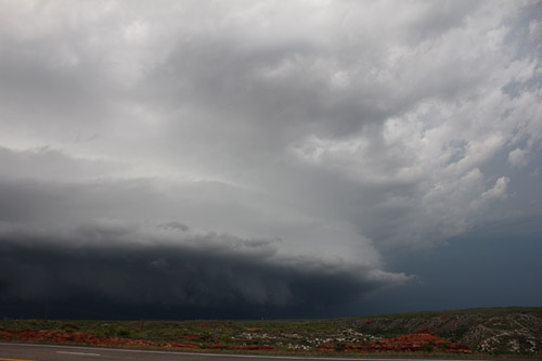
 Close up of the flanking line and wallcloud of the meso region. Not all of the wraparound precipitation was rain, some of it was large hail |
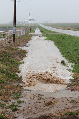 The precipitation core passed near to Hartley generating flash flooding |
 It's amazing to watch precipitation wrap around the wall and meso region especially when it can be lit by the sun, looking SW - Hartley |
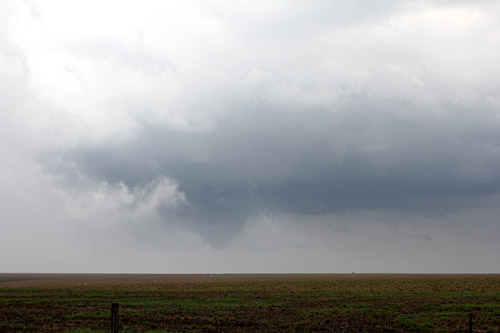
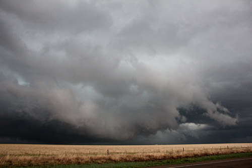
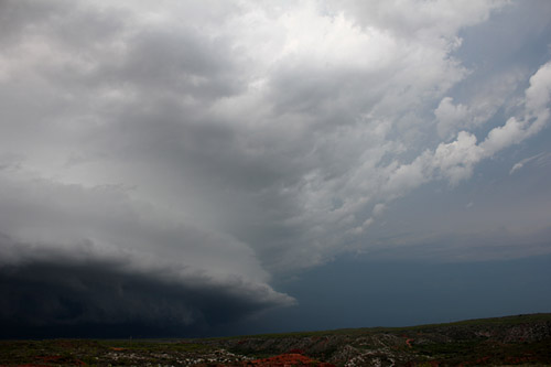
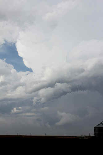 Occasionally the bludgeoning updraft core could be seen through breaks near the developing RFD |
 The storm was generating extensive hail shafts. |
 We noticed mist was aligned along the ground as we approached some large buildings - turned out to be hail fog. |
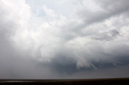
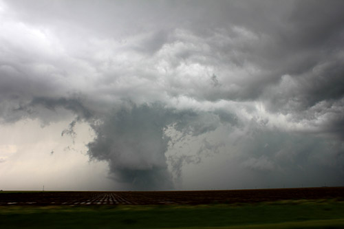
 The wallcloud appears form behind a rain curtain and was rotating rapidly. A developing funnel appears in the centre. |
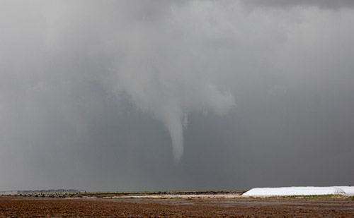
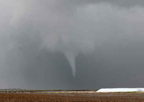 The tornado rapidly develops from the wallcloud. We could see contact with the ground for brief periods. |
Hartley tornado, Texas Panhandle
|
|
 |
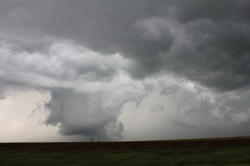
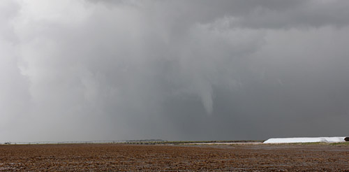 Hartley tornado recedes into the wallcloud prior to being rain/hail wrapped |
 We follow the wallcloud towards Dumas. |
 The wallcloud had a ring of mist rotating around it on the ground.West of Dumas |
 It was almost surreal to peer at the rotating wallcloud as it appeared through the groundmist. |
 East of Dumas, a rapidly developing lowering rotates and generates a brief tornado. |
 The small rotating wallcloud developed west of the main meso on the flanking line. |
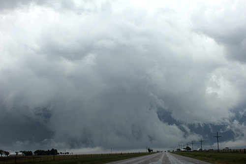
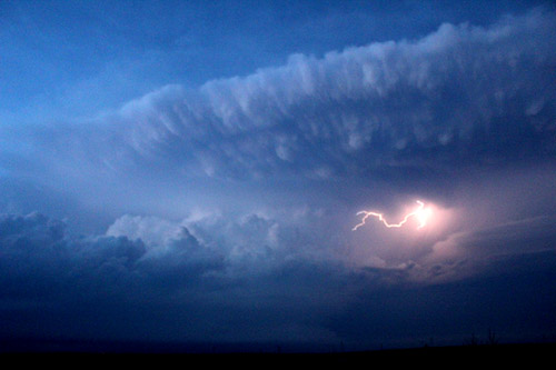
 There is a considerable amount of agitation under the flanking line. We call this the wake area, not unlike the wake left by a ship passing over the ocean (ship=supercell) Rapidly rising cells on the flanking line can take advantage of the vorticity eventually joining into the main wall / meso area. In this image the tornado makes contact for several minutes. |
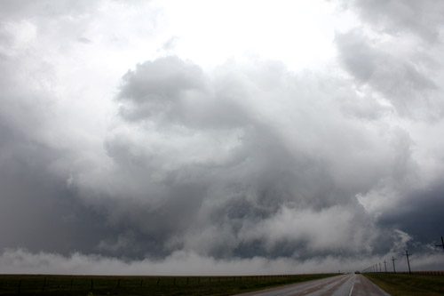
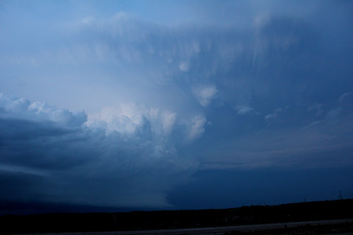
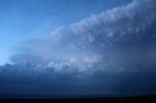
 West of Stinnett, the supercell retains a large wallcloud. At times we suspect the tornado was buried inside at this stage.
|
 The wallcloud developed an outer ring that rotated around the inner wall. |
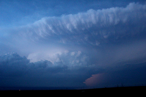
 After its tornadic stage, the storm evolved into an HP Supercell with a remarkable sloping flanking line feeding off rich moisture from the south. |
|
 Late evening view of the receding HP |
 |
 |
 |
 The wallcloud structure is retained, backlit by lighting. This was the only significant storm in Texas that day and had a very long life. |
|
| Stay tuned for tomorrow's episode... | |